
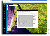
 “Teaching remote sensing? This web mapping application can be a very useful teaching tool. The web mapping application covers the whole planet, with mapping services that are updated daily with new Landsat 8 scenes. Access many band combinations and indices by hovering over the tools to the left of the map image and selecting among the following:
– Agriculture: Highlights agriculture in bright green. Bands 6,5,2
– Natural Color: Sharpened with 25m panchromatic band. Bands 4,3,2+8
– Color Infrared: Healthy vegetation is bright red. Bands 5,4,3
– SWIR (Short Wave Infrared): Highlights rock formations. Bands 7,6,4
– Geology: Highlights geologic features. Bands 7,4,2
– Bathymetric: Highlights underwater features. Bands 4,3,1
– Panchromatic: Panchromatic image at 15m. Band 8
– Vegetation Index: Normalized Difference Vegetation Index (NDVI). (Band5-Band4)/(Band5+Band4)
– Moisture Index: Normalized Difference Moisture Index (NDMI). (Band5-Band6)/(Band5+Band6)”